pocitadlo

Encounters

It doesn’t matter whether you fly a little ultralight, heavy GA airplane or a shiny glider – some weeks it happens rarely, others more often or even every flight depending on your activity. You meet another plane. It might be a pleasant surprise when flying along similar course for a while, circle a 5-meter thermal with a incredibly-long-winged fella or taken aback by a hostile Messerschmitt or a Hurricane which suddenly emerged from the sun disk. In such situations you may wonder who was that guy/gal, what type that airplane was or where the sky waves have taken them after you waved on each other and set sail towards you own adventures. To give you some hints there is a new lovely feature in the logbook’s map which I venture to call “Encounters“!

The blue circle indicates you have met an UFO in this location.

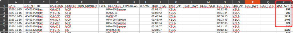
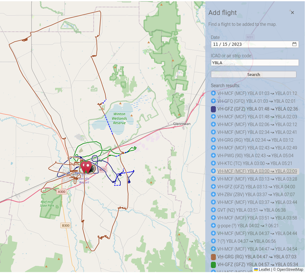
Since mid February you might have already spotted a small blue dots on the map. The blue circles indicate where you might have met someone – another plane that was around a near location and at a similar time to yours (or the one whose flight-recording map you are just reading).

By clicking the blue dot you get an identification (if known to logbook).

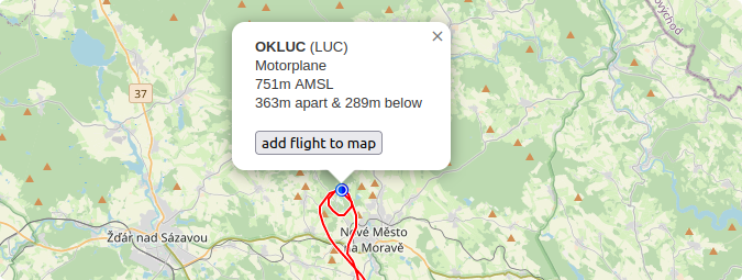
There might be gazillions of blue dots meaning you have probably met a contestants in a thermal, a single one when the tug plane was first encountered airborne during the tow or just a few random encounters along the track. Or just none.

The track of the other airplane can be added to the map to view both (or multiple) flights on one screen.

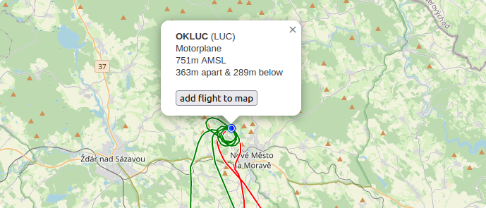
Current thresholds are configured to 500m apart in distance within 10 seconds-long time window. The next (repeated) encounter marker may appear after 20 minutes the earliest – hence if you fly in formation your path shall not be marked by blue little dots all the way. Furthermore, the detection is active for OGN and FLR traffic only as the ICAO beacons were causing too much confusion.

As of this moment the encounters-detection seems to work rather nicely, however, as the lookup is considerably CPU-intensive we will see how it behaves once the season begins. 🙂

OGN Logbook IV

There are some new nifty features in the OGN Logbook that you had not been told about. They are two rather nice and useful details some other fellow pilots already asked for or you might have desired.

Top Altitude During a Tow

For over two years you could have downloaded a .csv file in FlightOffice format that can also be opened in LibreOffice Calc or in any other spreadsheet tools. This file contains an summary of air traffic for each particular field for given day. The .csv file is available for download at top of the page in the page header as highlighted in the following screenshot.

Let’s assume you are from the Benalla airport, Victoria, AU (YBLA) and you have just started there as a tug pilot and local procedures require to record the maximal tow altitude for each flight. You can either note it down onto your kneepad every time upon tow release or alternatively check the appropriate column (col. H, MAX_ALT) in the .csv file where the logbook has recorded it for you (assuming you start the descend right after the glider release, the tow plane is equipped with well working OGN, transponder or other device and the OGN network coverage at your location is good).

The file structure is clear from the first header row and is I believe pretty self-explanatory.

    Multiple flights in the Map View

    This is a nice to have when you want to compare your friend’s flight with yours. Even when we agree to fly together in wing-to-wing formation, our paths usually split after a short while and many times it might be interesting which path the other one took. This feature is to visualise where our trails crossed without even knowing and where we joined on the cross-country flight under the same cloud again. For adding a flight just click on the large blue plus (+) symbol in the upper right corner of the map view.

    Here you can search for flights originating from the same airport (by default) of choose some other location your friend might have departed from. Furthermore, the date can also be modified if you want for example to overlay two or more flights from various days in the same map. Just remember that the flight-path retention period is not infinite, hence your early spring shenanigans won’t be probably not be available in late summer. Enjoy! 🙂